St. Croix River (Shoen Park Landing to Riverside Landing), Douglas/Burnett Counties (11.1 mi)

Some days, you realize that past ‘frustrations’ actually get you better results when you didn’t know it could/would happen.  It being a drought year, and a winter with little to no snow, I was anxious to get on the river in fear that the water would only go down.  Well, the last week or so it’s rained enough, and the water levels went up… and the river was awaiting us with better conditions than a few weeks ago!  I had said not to run it at low levels in the last post, and this had much more ideal wtaer levels than our first run.

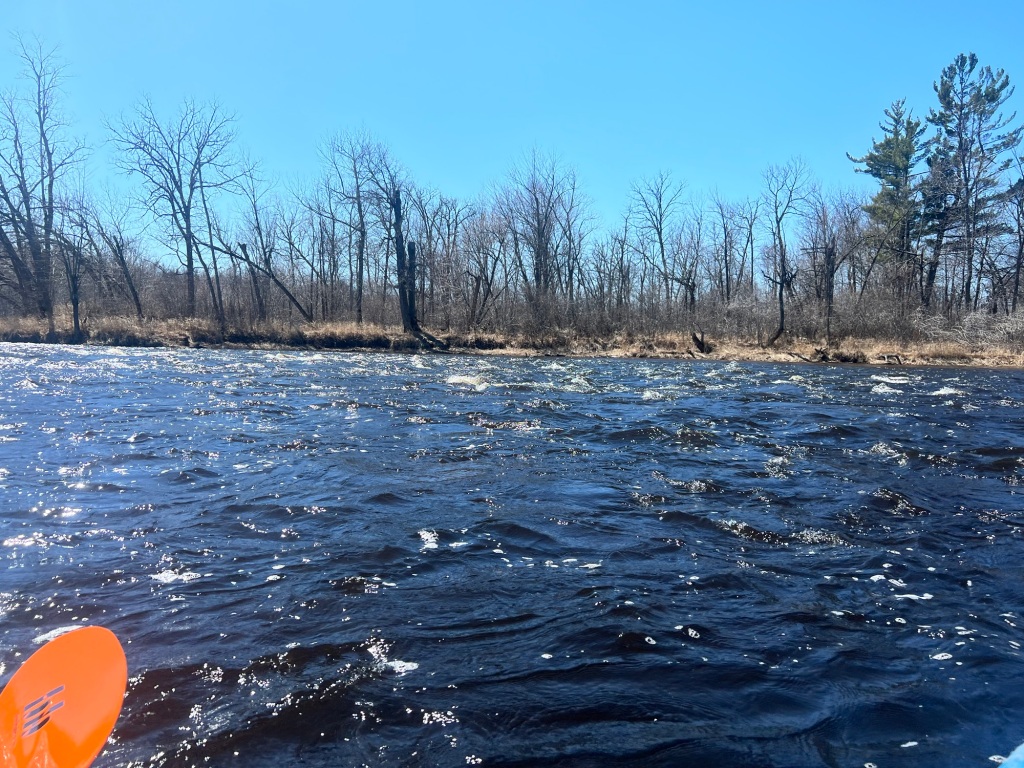
We started out at Schoen Park, where I could barely see the rocks that held me back as I tried to get to shore a few weeks ago.  The river was moving here, and we were on our way pretty quickly.  We weren’t paying a lot of attention to mileage, but knew that Big Fish Trap Rapids were supposed to be about 2 miles past Dry Landing.  I had read the descriptions of the rapids – the hardest on the whole river – before we took off, so we knew what to expect.  As we went along, I mentioned some riffles ahead.  We were into them.  And then… it seemed that they were … likely THE Big Fishtrap Rapids.  They are about 150m long, and not a hard bunch to get through at all (with good water levels).  The hardest part was that they continued on, and then were larger at the bottom (some waves that got us wet).  Ryan’s comment was ‘if these are riffles, then…’ Once through it, he also was thankful he didn’t have to build up to them and worry, but just went through them without stressing.  Ryan had seen a campsite right before them which confirmed that they were indeed the rapids we were looking for.  

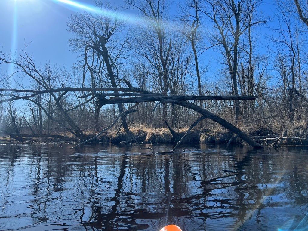
There’s another set of small rapids right under the CCC Bridge (Little Fish Trap Rapids) that spit you into Little Fishtrap Eddy.  The map is confusing on where you have to get out for the landing itself – we hopped out before the bridge, but the actual landing is after the bridge off of the eddy, and you walk across the dirt road to the bathroom. Launching into the rapids under the bridge is a trick, since you need to aim for the center of the opening to hit it correctly.  We both pulled it off and were on our way to the mostly flatwater portion of the day.  

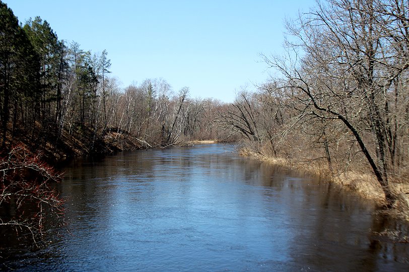
We continued on, a few miles until the confluence with the Namekagon.  Campsite 127.6 is a group site and doesn’t look like it is used much (with a nice grass bank to get out on).  Below campsite 136.5, there were some more riffles, faster water.  Eventually, we entered, or the Namekagon entered our path, the river widening.  I recently read that the Namekagon actually has more water in it at this point, which does make sense since it is longer where they meet.  I could see where Perkins Creek also entered the river from the opposite side not long after the Namekagon.

There are islands (including Big Island with Big Island Slough to river right) to go around and some faster water to contend with, but nothing too challenging.  There are three campsites in the last two miles of the trip.  They are all on river right, and the first one has a sign on an island to keep right (it’s not on the island, but you have to make the correct turn there).  The other two are on the same side too, and eventually the landing is on the right side (with its own campsite first) as well.   This was a fun section to do in higher water, and a first entering the confluence from this direction (I’ve entered it at least three times from the Namekagon/Totogatic, looking longingly north, wondering what’s around the riverbend).

Paddled May 4, 2024

I used NPS maps for this section.  I did reference Paddling Northern Wisconsin by Mike Svob and Canoeing the Wild Rivers of Northwestern Wisconsin by Northwest Canoe Trails, Inc. They recommended that the part above CCC Bridge be done in the spring with medium to higher water levels.  The second book has names for all of the rapids and fishing holes.  

Weather: upper 50s into the 60s, occasionally windy, cloudy turning to sunny

Time paddling: 3.25 hours

Water level: 2200 ft3/s at Danbury at 1 pm (it had peaked at 2430 the day before)

St. Croix River (Riverside Landing to Thayer Landing), Burnett/Pine County (13 mi)

It was too nice a weekend to not paddle.  And as I learned this winter, there isn’t always what you need to do the sport that you want to do.  With skiing, that’s snow.  With paddling, that’s water.  And water only gets lower as spring moves to other seasons.  And when there’s not much snow, and no snowpack, there aren’t spring water levels.  The St. Croix has good data for water levels, but it looked ‘average’ – and I don’t mean average for spring, but average, not high.  I didn’t want to paddle much for rapids since I was going alone, and didn’t want to get stuck either with ‘average’ water levels.  Based on that, and where Ryan was coming from (to shuttle me and bike on his own) I chose to paddle Riverside to Thayer.  

I’ve been to Riverside a few times, a takout point for the Namekagon and Totogatic (as there is nothing after the confluence of either of those rivers).  I recognized the landing right away, and got my kayak ready for the water.  As I neared the water, dragging my boat close, I saw the poison ivy berries haunting me along the edge.  It’s really the only reason  notice the plant in the winter, a warning to keep my distance!

Once on the river, I took in the fresh air and sunshine.  I was soon under the bridge, and as I do, I started naming the plants.  There wasn’t much for animals.  I came alongside the western bank, talking to my phone (or myself?) to record the plants I was seeing.  There was a pretty flower of a shrub (not showy, but showy for a wind-pollinated early spring flower – Myrica I believe).  “Who are you” I asked it and…. an animal upstream popped out.  What was a porcupine going to do?! It looked at me, wondering who was.  And then my brain came on board, as it slipped into the water, not twenty feet from where I was (though I was floating downstream quickly) – it was a beaver!  It slid into the water and swam upstream on the surface, not too bothered by me.  So the highlight of the day may have been in the first ten minutes.  The third beaver I’ve seen this year.  I think I’ve seen three other beavers in my whole life.  Interesting, amik is telling me something?

I sat there dazed, surprised that a beaver just came off the shore, looked at me for a few long seconds sizing me up, and swam away.  The kayak kept floating downstream.  I figured I should get straight with the river, and turned to watch the banks go by.  Most of this section had a wide open floodplain, with some higher hills on the east.  There are some rapids shown about 2 miles in, and I wondered if they would be rapids, as sometimes they overemphasize rapids on the maps to keep people safe.  I could eventually see them ahead, they made noise, and I was a bit nevous.  In the end, they were not much.  Riffles to class 1.  

Overall, this section is slow and wide.  There isn’t a lot of note along the way.  There are some islands that you go by in some parts. (I hadn’t checked all my books prior to the paddle, Pansy Landing is noted in my books, about 4 miles in, but is not mentioned in the NPS maps. I was not looking for it and didn’t see it.)  There are a few campsites (I stopped at the one by Crystal Creek (125.5) and it seemed like a quaint site right by the creek).  As the river nears Danbury, you can see the town. You can hear some cars too, but it’s not a super busy highway.  Interestingly, I noticed the birdsong picked up as I turned the corner and could see Danbury.  Having paddled the Yellow River, I believe that there is a landing right at the confluence that isn’t on the map.  (Checking my ‘Paddling Northern WI’ book, it does show a landing there. An older NPS map shows that it’s a landing that has a few and I noted that it’s a tribally owned landing). There were some people fishing below the bridge over the Yellow.  It didn’t look like a river that could be paddled from where I was at, but I do know that I came out there!

The river goes under the Gandy Dancer Trail (an old railroad bridge) and heads away from town, wide and slow still.  It got windy on this part, but I kept my pace and the wind wanted me go go upstream.  It did let up, and I could finally check the map.  I passed a campsite with a torn up sign at it.  I thought I was further than I was. The site was probably right near the Lower Tamarack River.  I soon passed Lower Tamarack Landing, first a dead end with an eroded riverbank, and then the actual landing with a sign, and realized that the campsite was likely one destroyed by the flooding a few years ago.  The campsite on the map is after the landing.  

I knew I was getting close now, and Ryan said to let him know when I could see the Highway 77 bridge.  Of course, with a mile left, my cell servi ce disappeared (which maybe I remember from these parts on other trips).  I saw the bridge ahead and knew that there was a rapid/ledge right before the bridge and to stay on the Wisconsin side of the river (the NPS map had that written on it).  I did finally get a text through, stayed left, and saw Ryan come under the bridge to get my picture as I finished.  I knew this landing too, I had waited here for Ryan to shuttle for another recent trip.  It was a beautiful day to get out on the river, in a spring that won’t yield a lot of snowmelt.  It’s a good paddle for lower water levels!

Other beings seen include: Reed canary grass, aspen, red oak, burr oak, sand barrens, red-osier dogwood, poison ivy, ash, hazelnut, white pine, blue dragonfly, silver maple, turkey vultures, wood duck, red maple eagle, merganser, mallard, frogs croaking, juvenile eagle, redwing blackbird, dead elm, swamp milkweed, baby nettles, raven, painted and soft shell turtles, smartweed, tamarack, white birch

Paddled April 14, 2024

I used NPS maps for this section.  I also have a few others for reference but didn’t read up prior to the paddle.  

Weather: sunny, 60s, windy

Time paddling: 3.75 hours

Water level: 1860 cfs near Danbury

St. Croix River (Thayer Landing to Nelson Landing), Burnett/Pine County (16.9 mi)

Last weekend was BEAUTIFUL – and Ryan and I had set it aside to paddle somewhere.  The first idea was the Flambeau, but being fall, we heard from a friend that it’s down and we might need to walk a bit.  Ryan isn’t a fan of ‘working’ for his nice paddle trips, so we looked around on the maps we had. 

We looked at the St. Croix River – one that had lots of info about it online.  We briefly ran into another roadblock – the NPS website said that most of it was ‘extremely low’ and wouldn’t be good to paddle.  Sigh – I guess a nice weekend in October doesn’t mean that the water is up, in fact, it’s the dry time of year… Another friend used to work for the St. Croix National Scenic Riverway, so I asked him where might be good – and went with his advice, both in location, and in the fact that if one can read the river, you can navigate it right now. 

We set out for Thayer’s Landing, unloading all of our gear.  Ryan took the car to the bottom and biked back to the start while I re-packed things so that they fit into both of our kayaks.  We chose kayaks because the river was a bit lower, and I realized that we hadn’t ever gone on a kayak camping trip together (lots of kayaking, lots of camping, and some canoe camping, but no kayak camping).  I hadn’t packed those boats before but found the space to fit everything.  Luckily, Ryan has a shorter sea kayak, which makes for more room for storage.  His other kayak yielded enough space to make everything fit pretty easily. 

We had lofty goals for how far we’d make it, but knew at the very least, we needed to aim for a campsite.  The river was wide and pretty slow, and we had gotten off to a later start than we had wanted.  We enjoyed the warmth of the late October sun, as we caught wildlife taking advantage of the beautiful (though smoky) day.  A few turtles on logs and many adult and juvenile eagles were flying around.  In this area Pease Hill and Hayden Meadow are on the Wisconsin side of the river.  Native people grazed horses, and early farmers cut hay in the meadow during dry years. 

On the Wisconsin side (left), we passed a group campsite that had to be reserved in advance at Governor Knowles State Forest, called the Sioux Portage Campsite.  I assume it is near the Sioux Portage Trail, which is indicated on the map in the Lowry book.  Not too much further on, there was the St. John Landing, which had a sign that said private, and no camping.  It did look like a pretty perfect place to stop, if not for the sign. 

We passed Little Yellow Banks Landing on the Minnesota side, as well as another campsite.  We were aiming for the campsite on the confluence with the Clam River, to see where we were at, and where the sun was at when we got there.  Past another site, we neared the Clam, and some fishermen were up that river in a boat.  We looked at the sun, seeing that the next private campground was likely another two hours away (we didn’t want to stay at a landing), and staked out our campground.  The campsite was nice – there was a ledge to put the kayaks, and we had to climb up the bank to the site.  Most campsites on the river are up; this one we could at least pull the kayaks out easily. 

Camping at this confluence was great.  We had a sunset to watch, set up the tent, cooked up some dinner, and made a fire.  The weather was perfect.  Warm, no bugs, just a chipmunk hoping for some of our food.  Knowing that, we put up a bear bag (I’ve found more of a raccoon bag), which took some finagling as the twilight faded out.  The trees didn’t have good branches for bear bags – mostly ‘up’ and not out, or no strong branches for our food to stay safe on. 

The nighttime – it was … one of the best nights I’ve ever camped.  ‘Who cooks for youuuuu’ and the most stellar stars I’ve seen this side of the border, the smoke had cleared out and I could get some pictures with my new phone.  Orion was out I found the Seven Sisters (Pleiades), the Big Dipper, they were all out there on the clear dark, too-warm-for-October night, as I got up to pee.  I lingered in it for longer than I normally would after a bathroom break from sleeping, knowing it was one of those magical moments that would be gone all too soon.  I could manage to not fall asleep immediately if I could absorb some of the magic in the air. 

The next morning, we slept in, cooked breakfast, and broke camp later than we had planned, but all was good.  An even warmer day, we had a little less than half of the distance to travel to the car. Downstream we went, past St. Croix State Park on the Minnesota side, with its two southern landings miles apart.  Sometimes the banks were high on one side or the other, and other times, they were low – the floodplain wide from many years of large floods.

A family of swans (adults and juveniles) paddled downriver, honking, and eventually decided to fly upstream as we neared – the lower water meant we needed to follow them though the river was wide.  Flocks of sandhill cranes coalesced above, and I imagined them saying things to each other like ‘Hey – are you headed to Florida?”  “Me too!”  “It’s good to see you after these many months!”  It was around here that I was not paying attention to reading the river and briefly got stuck, as Ryan floated on.  As my friend said, if you are reading the river, you can get through it! 

We went by Mouse Island, which may have been created by sand filling in around sunken logs from the logging era drives.  Settlers later pulled these ‘deadheads’ out of the river to use as lumber.  At least in the 1970’s when the Lowry book was written, there were still logs from that era in the river and back sloughs.  There are lots of logs to see – some at the beginning of islands, but I guess I always think they are more recent – from floods or newer trees falling into the river.  I guess I won’t know, but it’s interesting to think that islands were created from the logs!

Not far after Sand Creek Landing (the last landing in the state park), Norway Point Landing was on the Wisconsin side.  This was the area where we had the most wind – it was coming upstream at us, as the river had turned to the SE.  Ryan had been worried the wind would pick up while we were out, as the forecast said it would, but while we were paddling, we had a few gusts here and that was all.  (The drive home was another story).  I had taken out here when I paddled the bottom of the Clam River and needed to continue to the first landing to get out. 

2.5 more miles and we were to our landing, passing many islands in the meantime, including Taylor Shanty Island (named after an early trapper who had a cabin there) and Nordstrom Landing (a campsite is on the Minnesota side across from this – looked very flat and great to take out at).  According to the Lowry book, Nelson Landing was also known as Head of the Rapids Landing.  There is now a landing on the Minnesota side (not on the main channel) with that name, which is not named in the book (in the book it is on Kettle River Slough). Nelson Landing was the site of an old sawmill and people forded the river here on the tote road to the mill.  It is also said that the first resort on the St. Croix was at this location in 1920.   

Beings that we saw out there: lots of silver maple, Virginia waterleaf, bindweed columbine, Canada goldenrod, barred owls, virgin’s bower, white oak, bird nest, swamp white oak, nettles, common milkweed, white pine, red pine (more downstream where the landscape looked scrubbier), vervain, white birch, white spruce, wild rice, kingfisher, bald eagles, maybe turkey vulture, swans, sandhill cranes, turtles sunning themselves, chipmunk at the campsite, smaller ducks, great blue heron

Paddled October 22-23, 2022

We used maps from the NPS (both from 2010 and 2020+), Canoeing the Wild Rivers of Northwestern Wisconsin by Gerald L. Lowry, and Paddling Northern Wisconsin by Mike Svob. 

Weather: clear/smoky, 50s-70s

Clam River (Charles Tollander Park/Highway 25

Ryan has been itching to go paddling this summer – so we finally went.  My request was a place I hadn’t written about yet (but I could have paddled before I started this blog).  He looked through the books we have for all the rivers in NW WI.  He suggested some locations that I’ve written about, and then we settled on the Clam River.  Partway through the paddle itself, he expressed that he wanted a relaxing paddle – and this river, while beautiful and little paddled, has many fallen trees – leaving us to portage or duck a lot throughout the route – not exactly what he was looking for.

We started at Charles Tollander Park on Highway 35.  You can do around a bend/peninsula (using a decent landing) or start near the bridge, cutting a bit off, and having a bit more trouble getting into the water.  We chose the easier put-in, but be warned, there is a shooting range around the bend.  It didn’t sound close when we started, but there is a target right next to the river.  The person practicing was parallel to the river, shooting ‘downstream’ and had ear protection – I don’t think he was ever aware of us, but it was nerve wracking going by, with how loud the shots were.  I would recommend avoiding this portion if you have PTSD related to shootings, or jump easily at loud random noises. 

We continued on, under the bridge, happy to leave the shooting range behind.  The rest of the paddle was much more relaxing emotionally, though not physically.  The book claimed that the section (from Highway 35 to the St. Croix River) was 20 miles, and Ice House Bridge was ‘about halfway.’  Based on my tracking, it was closer to 13 miles – a bit longer than we expected. Without a phone, it would be usually hard to tell how far we had gone.  We knew when we crossed under a railroad bridge (the Gandy Dancer Trail) and Wicklund Bridge (Old Highway 35) early on, but from there to the end there are few to no cues to easily take note of.  The river winds left and right, and many times you see where you are going or where you’ve been on a hairpin curve.  There was one area you could choose to go either way – we went right (a future oxbow), and left was shorter.  The way we went, at least, we did have to get out, I cannot speak to the other direction.

There are lots of downed trees on this section of the river.  Depending on the water level, some you can go under, or over, or you have to get out.  I stopped counting how many times we had to get out, but know that we could squeak around a corner just as many times, and I could make it under a few logs (sometimes ducked really low) in my kayak a few times.  More annoying were the sandbars that seemingly came out of nowhere.  We tried to avoid the logs, going where it looked the water went, and all of a sudden it was too shallow to move. 

While getting out for the logs and sandbars is a hassle, the natural qualities of the river are nice.  Logs long fallen, and not moved for decades while they decompose have plants and trees growing on them (and those logs aren’t the problem ones).  Banks cut away, floodplain forests and few homes along the way make for a beautiful paddle if you are willing to take on some extra physical exertion getting in and out.  A favorite part of the paddle was meeting an otter family!  While they are seemingly playful, we knew to avoid getting too close as we dodged between two fallen logs to get past the cute little guys.  They chattered and swam around, and we knew to keep a respectful distance or risk a dangerous situation.  As we neared the end, every turn I hoped for the bridge.  It was getting long, and there were signs of human habitation (a few homes).  At long last, the bridge appeared, and we took out on river right, after the bridge.  There is poison ivy at this landing. 

At the end, Ryan had to bike shuttle and a storm was coming in.  I stood with our kayaks, reading Fungi magazine, waiting for him to return.  Drizzle, light rain, bigger drops, I stayed under some protection of an elm, but not too close to the forest as the poison ivy was everywhere.  Five minutes before Ryan arrived, the skies let loose.  Almost… almost.. we still had to put the kayaks on the car and were soaked through by the time we left. Drenching rain, flooding the streets of Siren came, and we paused in Hertel (pause.. or stopped for a half hour) to wait out the sheets of rain that were near impossible to drive in.  Luckily the book wasn’t more off on the distance from start to finish, and we just got wet once out! 

Beings seen on this paddle include: silver maple, reed canary grass, dogwood, sensitive fern, arrowhead, ash, swamp white oak, honeysuckle, stinging nettle, vervain, Joe pye weed, swamp milkweed, monkeyflower, black-eyed Susan, White Pine, red pine, Lotus, bracken fern, grape, basswood, buckthorn, poison ivy, arborvitae, crow, barnyard grass, wood nettle, Canada goldenrod, prickly ash, aspen, birch staghorn sumac, tag alder, bracken fern, four species of damselfly bergamot, boneset bottlebrush grass, common milkweed, common mergansers, horsenettle, clearweed, water hemlock, royal fern, Virginia creeper, yarrow, bellflower, raspberry, juvenile eagle, dragonflies, white spruce, red pine, thistle, soft rush, spike rush, Green-winged teal, purple loosestrife, frog, dragonflies, dogbane, grass-leaved goldenrod, interrupted fern, mullein, beaver cuts, kingfisher, plover Canada goose,  mallard, cardinal, turtles, clam midden, deer crossing the river, monarch and other butterflies, horseflies, deerflies, sparkle water and otters!!

Source used was Canoeing the Wild Rivers of Northwestern Wisconsin by Gerald R. Lowry

Paddled July 31, 2022 (and the first time – Nov 2015)

Weather: mostly sunny, 70s (to rain)

Namekagon River: Whispering Pines to Riverside Landing Overnight (St. Croix River), Washburn and Burnett Counties (25.3 miles)

I was looking for a good section of the Namekagon to paddle with a new friend.  My favorite part is towards the top of the river, but I know that the lower Namekagon is a favorite of many, and I had not completed a blog post about this section, so chose Whispering Pines to the end (and into the St. Croix River) for our overnight trip!

We met up at Riverside landing, so our shuttle wasn’t hard to figure out – just leave a car and drive to the start!  We then headed to Whispering Pines, where we had the landing to ourselves. For a little while. We had unloaded the canoe and gear, and I was trying to pack things and put things back in the car that I didn’t need when multiple outfitters showed up with tubers – three loads I believe within a short amount of time.  I moved the car out of the way, and continued to pack, letting two groups of tubers get out ahead of us.  One was a bachelorette party.  It is hard to get to the water at this landing, well, with a heavy canoe.  It’s steep though has a ramp that is non-slip.  A bystander helped us get the canoe to water level which helped a lot given the angle at which the ramp was. 

We were off!  The tubing groups weren’t too rowdy yet (I’ve passed those by Trego before) since they just got onto the water, and were very friendly.  The river is peaceful and wild.  We identified trees and flowers on the shoreline as we went, and also passed a few more tubers.  We passed a father and son camping on a peninsula, hanging out in the water, and a family tubing.  We actually leap-frogged the family when we stopped for our lunch.  Lucky for them, we ran into them at the Hwy 77 bridge – they had been looked for the takeout for Heartwood Conference Center, and I looked it up on my phone – we were well past their takeout (I am not sure where the takeout was, but it was 2 miles back on the highway).  I called there, and said they were at the highway, wanting to get picked up, a bit thirsty and hungry, as their 1.5-hour trip had turned into 4 hours.  I think they would have gotten out a bit after Howell Landing, but am not sure and did not see any signs.  The man said that next time he would ask more questions!


We continued on, past Fritz Landing and McDowell Bridge Landing, a beautiful day to be out.  We decided that we would at least make it past there to the latter campsites and then we would be over halfway done.  We camped at N8.4, which was easy to get out (most of the campsites have steep exits).  Campsite N8.8 also looked easy to get out at, but some people were picnicking there.  (Later on, N3.5 looked like a nice takeout too).  The campsite was off the main river, we could hear people coming down the main channel, but most did not go right by, it’s across from an island on a side channel. We paddled upstream 20 yards to get to it. We explored a bit – there is poison ivy there, and someone had recently weed-whacked, which seemed weird since the juice would have been spread and we were also walking on the dead poison ivy – not the best idea. The site was nice, with a toilet and a trail towards a residence that must be off of Webb Creek Road.  We could hear some people chatting at times, and ATVs/cars driving a bit.  There is a no trespassing sign, so we did not venture past that.  In the morning, there were lots of dogs barking, which may make the site less desirable to sleep at.  I also must have gotten into a nest of ticks, as I had 4 teensy weensy ticks in my toes in the morning, and 4 more on my legs.  So tiny you could barely see them!  Overall, we enjoyed the site, with a picnic table and lots of space to put tents, a good bear bag tree and an easy place to put the kayak and hang out on a sandy beach by the water.  There was even a small amount of wild rice in the river – going from the floating leaf stage to erect.  The water wasn’t flowing fast on this part of the river. 

Young wild rice on the river

In the morning, we got a start, not super early, but apparently earlier than all the other sites nearby! Each of the next 4 sites were taken, people still occupying them.  The last has a short jaunt upstream to the Totogatic River, and it was a group of fishermen – we didn’t see them in the morning, so assumed that they had paddled up the Totogatic to fish and could float back to their site.  After that confluence, the Namekagon has a different nature to it – it is wider and more shallow.

This day was not as enjoyable.  Not for the weather, or maybe that played a role in how active the deer flies were!  The middle part of our trip had a pretty sandy bottom, making shallow areas not too difficult to go through.  We didn’t enjoy the scenery quite as much as I watched tens of flies weave between us and had a group of dead ones growing at my feet. Others were heartier, and after a good smack they would get up and fly away. We did try to get away from them by getting out at a campsite, it worked for two minutes, a nice reprieve from the buzzing, but they again surrounded us.   

Heading downstream, it becomes more rocky, where the ‘rapids/riffles’ are shown on the national park map.  It was pretty shallow so I had to get out a few times to lighten the load in ankle deep water.  Staying towards the edges generally would work, but it can be hard to follow the deeper channel.  I kept thinking we were at the confluence as the shoreline wavers and you can’t quite see around the corners (anticipating another river).  The confluence with the St. Croix River gives a deeper chance to float without getting stuck.  At the left corner of the confluence there is a private cabin. 

Once on the St. Croix, we had a few miles to go.  We floated a bit and snacked, and continued paddling downriver to our destination.  It got pretty shallow on the river, lots of rocks, likely where the ‘rapids’ are shown on the map.  It was the hardest part to get through, between the really shallow small rocks and later large rocks to dodge.  The landing is after a few campsites, and directly after one connected to the landing – the ‘campsite’ landing is much larger than the actual landing itself, though the landing itself is easier to get out at because of the actual drive-in landing.

I used the NPS maps while on the river for this section. The sections are also in the books: Paddling Northern Wisconsin by Mike Svob (1998) – the section I paddled on map N-3/4; and Canoeing the Wild Rivers of Northwestern WI by Gerald R. Lowry (map N-1.  

Blue vervain, swamp milkweed, joe pye weed, silver maple, red/white/Jack pine, white birch, bulrush, arrowhead blooming, white water ilies, rocky san, rockdy iny. Shallow in parts. Wild rice by campsite. Muskrat? Kingfisher. Heron.

Paddled July 10-11, 2021

Weather: sunny, 70s/80s

Totogatic River – Thompson Bridge/River Road to Namekaon Trail Landing (Namekagon River)(~10 miles)

31646760_10101695698974311_1151432671373557760_n

Having not been on the Totogatic recently and knowing it can be a little bit, shall we say, rustic, Ryan and I were pleasantly surprised at the simplicity of paddling this section. It was our first paddle of the season in Wisconsin! The river seemed high and swift enough, and maple flowers were budding out and blooming, welcoming spring and warm weather.

The river winds a lot, and using Canoeing the Wild Rivers of Northwestern Wisconsin, I was able to track where were on on the map almost the whole time. The book said there was a spring on a high sandy bank, but there is a home there with a person outside, so we didn’t explore the area to find out if that was true. E missed seeing County Line Road on river right, but I could figure that we had passed it because it was on a relatively straight segment of river.

After the straight part of the river, we entered the area the book calls the “Dismal Swamp.” I found it a Not-So-Dismal-Swamp, maybe due to the time of year. There was lots of waterfowl, a beaver, and a clear path. The river did run through the woods, reminding me of bayous in the south. The Dismal Swamp lasted a long while. There was a very short segment that seemed not so swampy before the confluence with the wider Namekagon River.

To get to the first takeout on the Namekagon, you have to paddle another mile. There were still swampy banks along this portion, and a few islands to go by. There were also 3 campsites that were well established and marked for paddlers.

Flora and fauna along this segment of river incuded Jack pine, red pine, white pine, silver maple, basswood, tag alder, white birch, ash, geese, merganser, deer and many other ducks.


Paddled April 29, 2018. Pictures by Ryan Urban.

North Fork, Clam River (County EE to second crossing of Sand Rd)

The North Fork of the Clam River on County H in Washburn County may look very tempting from the bridge, but it is not worth the effort put forth to paddle it. The planned route was about 10 miles from the trout stream parking on County EE (just West of County H) to County B.

I wouldn’t suggest this portion of river to anyone. As I was doing it in the spring, the water was ‘high enough’ but the river/stream is definitely not particularly navigable. The trip involved lots of dragging the kayak across rocks (no amount of scooting would get me down the river.) When the water was deep enough to paddle in, the tag alder bowed over and into the river making it a fight from above to go downstream (or not end up in each and every shrub.) I had to duck under them, some pulling water, dead leaves and what I came to call ‘tag alder spiders’ all over me. I am not afraid of siders, but this experience was a little bit much.

1907483_10100718753685501_4798088959642475609_n

I did meet two fly fisherman along the route. One of them told me that he had never seen someone paddling on the river in 30+ years of fishing there. At that point I was still in good spirits and thought that was odd. The other fisherman said that I was on the horsehoe turn of the river and would cross Sand Road again in a long while. I don’t think I quite believed him how far it was to get back to where I had been, half a mile down the street. I definitely believed him when I came to the next road, only to look left and see where I had last gone under a bridge was not far at all. I had crossed this road a few hours earlier and had only gone 1-2 miles. https://www.google.com/maps/@45.7305221,-92.1369357,14z

I ended up taking out at Sand Road’s second crossing with the North Fork of the Clam River after about 7 hours, 4 miles of paddling, due to frustration, being covered in spiders and dirt, dragging my kayak and ducking under the tag alder. This portion of the Clam River was very difficult and wouldn’t be a good potion to paddle.

The redeeming part of the trip was the blue damselflies that flitted near the shoreline for a lot of the trip.

1533754_10100718753780311_123291243402907522_n